

Storm to bring ice, snow, and strong winds to Ontario
- Weather Desk

- Dec 27, 2025
- 2 min read
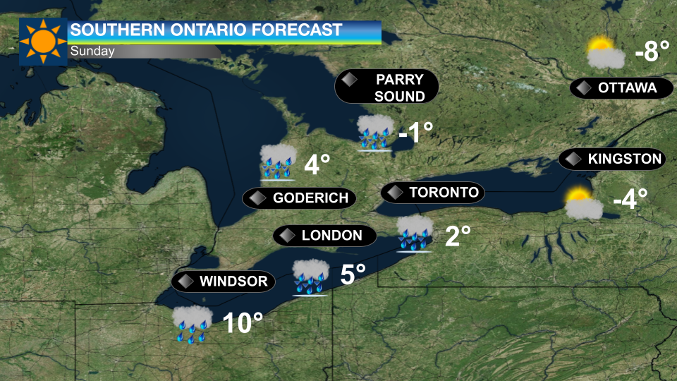
Sunday
On Sunday, a complex weather system is expected to affect much of Ontario, bringing freezing rain, rain and possible thunderstorms. Icy conditions are forecast for parts of northeastern, eastern and central Ontario, including higher terrain and areas of the Greater Golden Horseshoe, with slippery roads and walkways likely.
In southwestern Ontario and the Golden Horseshoe, a brief period of freezing rain may transition to rain, with rainfall totals of 20 to 40 millimetres and localized flooding possible. Patchy freezing rain and ice pellets may develop in northeastern Ontario early Monday, while heavier rain and a risk of thunderstorms could bring localized totals up to 50 millimetres in southwestern Ontario and the Niagara Peninsula.
Across northeastern and central Ontario, heavy snow, strong winds and blowing snow are forecast east of Lake Superior, where snowfall totals could reach 40 centimetres, and wind gusts up to 90 km/h may produce blizzard conditions, power outages and major travel disruptions, including along Highway 17.
From Chapleau to Timmins, snowfall amounts of up to 50 centimetres are possible, with local blizzard conditions near Lake Superior and likely disruptions along Highway 11. Elsewhere across northeastern and central Ontario, 10 to 20 centimetres of snow is expected, with ice pellets and the risk of freezing rain south of Sudbury, including Manitoulin Island, creating hazardous travel. Additional snowfall of up to 15 centimetres is forecast from Marathon to Little Abitibi beginning Sunday night, with the worst conditions expected near Lake Superior.
Monday
Eastern and central Ontario are forecast to see a prolonged freezing rain event into the morning or early afternoon, with icy roads, tree damage and possible utility outages. As temperatures rise, rainfall amounts of up to 20 millimetres are possible, followed by wind gusts near 60 km/h.
Southeast of Lake Huron, blizzard-like conditions are possible in snow squalls, with wind gusts up to 100 km/h, near-zero visibility, heavy bursts of snow and a risk of power outages as temperatures fall rapidly below freezing. Strong winds of similar strength are also expected southeast of Georgian Bay and along the northeastern shores of Lakes Ontario and Erie, accompanied by brief heavy snow, blowing snow and developing snow squalls into Tuesday.
Across southwestern and central Ontario, including the Golden Horseshoe, rapidly falling temperatures may lead to icy conditions Monday morning, while strong winds gusting up to 70 km/h and localized blowing snow could further reduce visibility and create hazardous travel conditions.

Comments